There are always days like this when backpacking and climbing. They are usually early on in the trip. Sure the summit push is the toughest day, but that is why we are there. But often the grunt is the approach to high camp. Or it is the slog up a steep hill to our first alpine lake after we leave the designated trail. You know it's coming and there is always that dread leading up to it. The packs are heavy and your legs are untested. That's when Dave Fischer says, "we got it to do".

While planning our trip Rhonda kept talking about the climb out of Leggett. And sure enough the elevation profile shows this anomally, a huge jump in the endless ups and downs. For the last two days we have been climbing along the Eel River valley. It's not a gradual climb. Instead there is this two steps up, one step down approach. If you are a math whiz, you could do a regression analysis and the line would a standard exponential growth pattern. The profile looks like those graphs printed out of your heart rhythm. And then there is this spike, as if the cat jumped out at you at 2am when you get to go to the bathroom. Yikes!
We left Garberville after a good rest and cruised steadly up the road. Lunch was this outside hippy grill near Standish Hickey. A grilled turkey sandwich with avocado (we are in CA) and fresh squeezed organic lemonade to cool the 90 degree temps. Then we left the 101 for the CA hwy 1, and we got it to do.

It was a long and winding grunt up, at 7+%. I found my granny gear and left it there. The sign at the bottom said no motor coaches or pulled campers over 40' but that didn't stop them. Up we went in the heat. We left the hippy grill with our two 24oz water bottles full. The map said 28 miles to the next services and I was worried I would run out. We stopped three times on the climb up, getting the heart rate down and giving the legs a break. As the garmin showed us nearing and going over 1800' ( I know Louie, it doesn't seem that high or tough, but you are not here), I kept thinking the next switchback would be the last. Finally we rounded a corner and there was no more up. Now the reward.
For the next 12 miles we cruised down and around, clicking off the feet towards the ocean for the first time in 2+ days. My mountain experience and what little physics I had in school taught me that the temp should increase as you descend. At half way down we pulled over to cool the brakes, but also add some layers. Rhonda put on a jacket and I added my vest and arm warmers. Arm warmers could be a stylish shirtless sleeve. Mine are black and cut the wind and keep my arms warm, hence the name.

When people ask me where I grew up, I say, "I haven't". When mom said 'don't touch the stove top because it's hot', I did, and so I just had to see how hot my disk brakes really got. I'm glad I bought my bike with disk brakes. They really work and they get really hot!
By the time we reached bottom the temps dropped to 58 and the marine layer hid the yellow orb in the sky. And then another hill! What? A hard 500 foot climb back up before we could see the sea.
Our water was running low and we still had 9 miles to the next "full service" village, Westport. The one store was able to provide us directions to the garden water spicket and sold us some Grandma's cookies and told us the next town with real food and camping was 10 miles away. Our map said 13, and my legs thought it was 20. From now on the coastal road will be a series of steep curves descending the washes, followed by steeper climbs, one after the other. They would be fun on my road bike with no traffic.

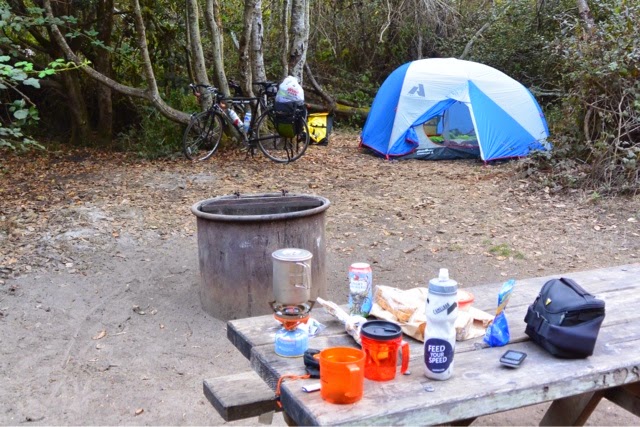
We found a hiker/biker camp with a nearly full service market, with ham sandwiches and a small bucket of potato salad. I'm writing this as proof they didn't give us food poisoning. We shared camp with an older German couple. We shared coffee this morning before we headed into Fort Bragg for a bike shop and bike maintenance, and more laundry.

Our coffee brought back memories of Tug, Jim, and Tina. I hope they are well and wonder where they are. I miss them.
No comments:
Post a Comment